Discovery

Romans in Merthyr Tydfil

It has long been established that the Roman Army constructed a fort at Penydarren (c.AD75), Merthyr Tydfil, to protect the auxiliary unit of troops (normally about 500 men) stationed there. This fort was one of a network of auxiliary forts which were usually positioned between fifteen and twenty miles apart. These forts were probably constructed during the governorship of Sextus Julius Frontinus following the establishment of a new base at Caerleon, or Isca Augusta, for Legio II Augusta (The Second Augusta Legion). The purpose of the auxiliary unit was to garrison forts in recently subdued areas, defend the frontiers, maintain order and protect supply routes.

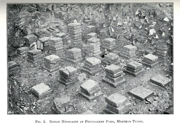
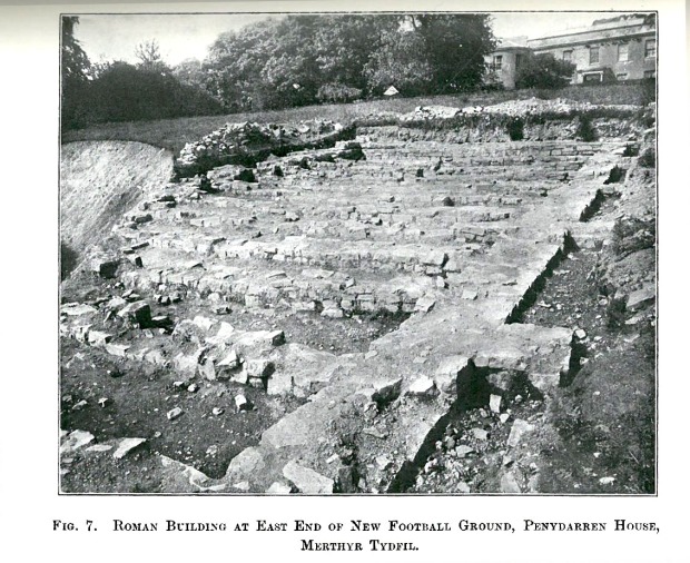
The first evidence for Roman occupation in Merthyr Tydfil was noted in 1786 during the construction of Penydarren House for the Iron Master Samuel Homfrey when both Roman bricks and tessellated pavement (mosaic) were revealed. Later, between 1902 and 1904 during the preparatory groundworks for construction of the Merthyr Tydfil Athletics Club track and later football ground, the remains of a Roman granary, a building with a hypocaust system (Roman central heating) and a water-well were discovered. This was the first time that the site was considered to be that of a Roman fort, following the examination of the site by Dr F Haverfield of Oxford University. Rescue excavations were later undertaken in 1957 by Dr Brenda Heywood from the University of Cardiff, supported by university students and pupils from a local school. A corner of the forts defences was excavated, revealing a rampart that consisted of a clay and turf bank 8.25m wide that possibly stood to height of 1.6m above a stone base. This defence was supported by two ditches 3.96 and 3.05m wide respectively, separated by a berm at 2.74m wide. In addition, a small section of possible via sagularis (the perimeter road running behind the rampart on the inside) was found within the east rampart and the remains and traces of two ovens in the intervallum (the area found between perimeter road and rampart). From the excavation and its results, it has been postulated that the fort undertook a second phase of building and was occupied until c AD 140.

fig2b3-2broman2bhypocaust2bat2bpenydarren2bpark2bmerthyr2btydfil

fig2b7-2broman2bgranary2bbuilding2bat2beast2bend2bof2bnew2bfootball2bground2bpenydarren2bhouse2bmerthyr2btydfil

Civilian settlement (vicus) and industry (iron working) can often be associated with forts of this type. Outside of the fort at Penydarren the remains of a bathhouse and evidence of a small cemetery (three Roman cremation urns) had been discovered, but little else. That is until local historian and metal detectorist, Mr Anthony “Shirley” Thomas noticed unusual looking rectangular cropmarks on the aerial photographs of the land surrounding Merthyr Tydfil. Mr Thomas brought these photographs to the attention of the Glamorgan-Gwent Archaeological Trust who confirmed that these cropmark could indeed be Roman, most likely associated with Roman metal working in the area, but further work is required to confirm the discovery. Rather excitingly, it now seems possible that Merthyr Tydfil’s origins as an Iron Town could stretch back some 2000 years to the Roman period.

Merthyr Tydfil Leisure Trust, working in partnership with Cadw, Merthyr Tydfil County Borough Council and the Glamorgan Gwent Archaeological Trust are planning to investigate the cropmarks first noticed by Mr Thomas as part of a community archaeology project. If you would like to get involved, learn more about the project and help discover the origins of Roman Merthyr Tydfil and learn how archaeologists investigate and record archaeological sites then please contact the Merthyr Tydfil Leisure Trust for further information.

GeoFest 2015 Festival Family Fun-day

Stuck for things to do with the kids today? GGAT are at the GeoFest 2015 Festival Family Fun-day at Craig-y-nos Country Park in the upper Swansea Valley.
Plenty of activities for young and old including zip wire, woodworking, crafts, geology and wildlife displays. Refreshments available on site.
Wednesday 27th May 10am – 4.30pm
Venue: Craig-y-nos Country Park, Upper Swansea Valley SA9 1GL
Cost: Free – but there is a charge for car parking (pay-and-display)
Further info: phone the NPVC on 01874 623366
Dogs: well-behaved dogs welcome!

Gower Landscape Partnership-Archaeological Training Workshop

Come along to the first ‘Finding Our History’ training session – Landscape Detective

Understand how maps are used in archaeology and historic landscape studies. Have a go at interpretation of cartographic information and Map Regression. Learn all about the Historic Environment Record, discover the new ARCHWILIO App and much more!

Festival of Archaeology 2014 Lookbook

Alas, the Festival of Archaeology Roadshow rumbles into the distance for another year!

But, nevermind, you can re-live all GGAT’s crazy archaeology fueled Outreach events by visiting our FoA Lookbook .  Here you can look back at a selection of photos from our many and varied events, helping you to keep warm until next years FoA rolls into town.

Festival of Archaeology 2014 Lookbook 2014-08-07 15-17-33


Hands on Heritage at Neath Abbey

Neath Abbey poster

The impressive remains at Neath Abbey will once again resonate to the sounds of medieval life this coming Saturday 19th July, as Cadw’s  annual Hands on Heritage event makes it’s welcome return to the site.

Showcasing a range of heritage skills, the event will bring the medieval period alive with sounds and smells and offers the chance for people to experience and explore a range of heritage crafts from stone masonry to wool-spinning and basket weaving, all set within this spectacular location.

Experts will be  on hand to demonstrate skills stretching back to the Cisterian period in Wales, while visitors will be able to have a go at some themselves, thanks to hands-on activities.

There will also be  activities for youngsters  to get involved with too – from building a wattle-and-daub hurdle, making a medieval tile or stained glass panel to having a go at our mystery excavation activity!

Archaeology for All!

The fantastic Festival of Archaeology is once more upon us, and GGAT kick off their activities for the festival with our flagship ‘Archaeology for All!‘ event on Saturday 12th July. 
This year the event is being held within the beautiful surroundings of Cyfarthfa Castle, in association with the Merthry Tydfil Heritage ForumThere will be Roman Cooking, Medieval Archery, Rural skills demonstrations, Archwilio, and that firm family favorite the Body in the Box!.  
The fun starts at 9:30am. Hope to see you there!  

Promontory Fort Survey – Week 2

Week 2 of our geophysical survey of a selection of Gower Iron Age promontory forts finds the team at Paviland.   The site is possibly more famous for the discovery of the ‘Red Lady’ during the re-excavation of the site by Reverend William Buckley in the 1800’s, than for the Iron Age promontory fort that crowns its peaks.

The fort, also known as Yellow Top,  has a central area roughly 40m by 44m, within which traces of settlement have possibly been identified using aerial photography.  On the landward side of the site are two lines of banks and ditches, around 32m apart, with the inner bank having a causewayed entrance.

GGAT First World War Project: Visiting National Shipyard No.1, Chepstow

As part of GGAT’s First World War Project, our Senior Project Archaeologist, Johnny Crawford and Outreach Officer, Paul W Huckfield (wearing his Military Specialist hat) are visiting the site of the National Shipyard Number 1, at Chepstow this afternoon.

The National Shipyards were proposed, and partially completed, by the coalition government led by David Lloyd George during the latter years of the war and were built in order to counter the large losses of British merchant ships being destroyed by German U-boat attacks in the Atlantic Ocean.

The shipyards were to be built so as to construct large numbers of “standard” cargo ships as rapidly as possible. In accordance with the Protection of the Realm Act, all Chepstow shipbuilding companies therefore came under government control and were expanded to form National Shipyard Number 1 (Chepstow). Shipyard Number 1, was one of three great shipbuilding centres established in the area, the others being Beachly and Portbury. Eight slipways were laid down in order to build ships of up to 600 feet (180 m) in length and of up to 300 tons.

The construction however was not restricted to just the shipyard, as over 6,000 skilled workers came to the Chepstow area from other shipbuilding areas in Britain. New housing was provided at three new Garden City sites at Hardwick, Bulwark and Pennsylvania (concrete blocks used to construct the houses and slipways being produced in part by German prisoners of war). Camps were also built for the workers, along with workshops, a power station and a new hospital in Chepstow.

In 1925 Fairfield Shipbuilding and Engineering Ltd bought and later dismantled the shipyard. In due course the company became Fairfield-Mabey Ltd who now specialise in steelwork for bridges and other structures.

Cwm Nash Cemetery, Vale of Glamorgan

Paul Huckfield, Arfordir Coastal Heritage project Co-ordinator and Rowena Hart, GGAT Projects, have been at Cwm Nash, Vale of Glamorgan this afternoon, filming with the BBC and ITV.  They have been talking about the cemetery located on the cliff top there and the human remains that have been exposed and on show since the storm of 5th of January.

Rowena does all the talking as Paul has man flu!

Filming the bones for the BBC news


Human remains have been repeatedly exposed by erosion and recovered by GGAT over the last 20 years, the last being in 2012. Learn more.   The remains have been carbon dated and all date from the post-medieval period.

This latest discovery is mainly thanks to Mr Morgan for his swift action in recovering the remains before they were lost to the sea.

The two grave cuts exposed by the January storms

The Trust have a Ministry of Justice license to excavate the rest, and the landowner’s permission, and are seeking grant support from Cadw to enable us to do so.